Training courses for drone surveying
Agisoft Metashape Online Training: Learn how to use the software step by step and receive a certificate.
Flexible online learning: Drone integration for trade and industry.
Highlights
- Comprehensive online training for DJI Terra
- Specially designed for LIDAR applications
- Integration of control points
- Export to various file formats
Suitable for
- Surveyors
- Civil engineers
- Architects and urban planners
- GIS specialists
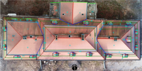
The fastest way to roof measurements by drone! Focussed training for Agisoft Metashape Professional.
Discover more
Surveying with a drone
Learn more about aerial surveying with our free guide.
Simply create 3D models
With the Airclip Cloud, you can quickly and easily create dimensionally accurate 3D models for your planning from your drone images.
Industry bundles
Everything from a single source. Drone, software, training and service for a carefree start.
Drone license
It all starts with the right training.
